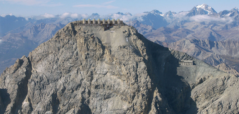
Der Berg liegt in geringer Entfernung vom Alpenhauptkamm, wo er auf der italienischen Seite die Wasserscheide zwischen dem Po- und dem Durance-Becken bildet; politisch gehört er aus historischen Gründen zu Frankreich. Der Chaberton-Pass (2 671 m) beherrscht sowohl das italienische Susa-Tal als auch das französische Briançon-Tal. Bis 1947 lag es auf italienischem Gebiet.
Eine leichte Wanderung auf den aussichtsreichen Gipfel, auf dem die Überreste des zu Beginn des Zweiten Weltkriegs zerstörten Forts liegen.
Die Festung kann mit den nötigen Vorsichtsmaßnahmen besichtigt werden, auch wegen der ständigen Präsenz von Eis in den Gebäuden.
Die Wanderung ist recht lang (15 km hin und zurück) und weist einen großen Höhenunterschied auf, wird aber durch die Militärstraße erleichtert, die mit konstanter Steigung und nie zu steil ansteigt.
Buy Unique Travel Experiences
Fill tour Life with Experiences, not things. Have Stories to tell not stuff to show
Use your credentials below and Log in to your account
OR
Log in with :
Sigh Up
Use your credentials below and Sign Up to your account
OR
Sign up with :
Password recovery
Enter your e-mail address that you used for registration
TRAVEL WORLD NEWS
Sell your First Travel Articles with Secret World.
Be the first to write an article about this place in a few clicks.
Content shared
Thanks for sharing your experiences on Secret World. we appreciate your
contribution to offer the best travel insights in the world..
NEVER STOP
DISCOVERING
THE LARGEST DIGITAL TRAVEL GUIDE
In compliance with the European General Regulation 679/16 (GDPR),
we inform you that this site uses technical as well as non-technical cookies,
including from third parties, to offer a better experience and to take into account your navigation choices,
through profiling. By clicking OK, continuing to browse or interacting with the contents of the portal,
you consent to the processing of your data through these cookies. The information is available by clicking here.