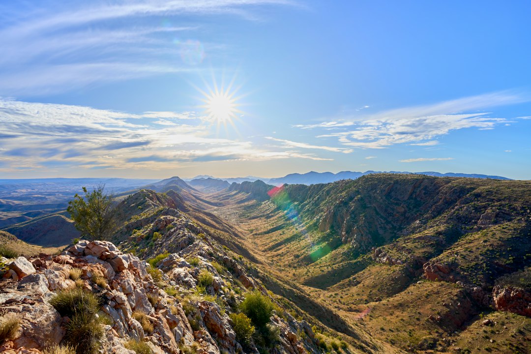

The quartz shines under the ten o'clock morning sun as one travels along the ridge of the West MacDonnell Ranges, and the silence is broken only by the wind flowing through the twisted branches of the ghost gum. The Larapinta Trail stretches for 223 kilometers through some of the oldest rocks on the planet, geological formations dating back over 300 million years, cutting through the Northern Territory of Australia with ridges of reddish quartzite and deep gorges where water persists even in the driest months.
The trail connects the Telegraph Station of Alice Springs, a telegraph station built in 1872 along the line that linked Adelaide to Darwin, to Mount Sonder, which rises to about 1380 meters above sea level and is considered sacred by the Arrernte community, the traditional custodians of these lands. It is not a path for those seeking comfort: it is a journey that tests the legs, navigation skills, and the ability to be alone with the landscape.
The trail and its sections
The Larapinta Trail is divided into 12 sections of varying difficulty, each of which can be traversed independently. The first sections, near Alice Springs, cross relatively accessible terrain with moderate climbs towards Jay Creek and Simpsons Gap. Simpsons Gap is one of the most recognizable stops on the route: a fissure in the rock where the quartzite walls rise vertically and where, in the early hours of the morning, it is possible to spot rock wallabies coming down to drink.
The central sections become more challenging, with exposed stretches on the ridges and steep descents towards the gorges. Ormiston Gorge, reached around section 10, hosts one of the largest permanent waterholes along the entire route, a natural basin surrounded by red walls and white-barked eucalyptus trees. The last section, which leads to the summit of Mount Sonder, requires a night departure — typically around 4 in the morning — to reach the top at dawn and enjoy the view over the desert before the heat becomes unbearable.
The geology and the landscape
Walking on the Larapinta Trail means crossing an open-air geology manual. The quartzite ridges of the West MacDonnell Ranges are the result of orogenetic processes that occurred hundreds of millions of years ago, and erosion has left exposed layers of rock that change color with the light: bright orange at noon, purple and ochre at sunset. The riverbeds, called creeks, are almost always dry, but the permanent waterholes in the gorges represent vital points for the local fauna.
The ghost gum — Corymbia aparrerinja in scientific classification — are the most characteristic trees along the trail. Their smooth white trunk contrasts with the red of the rock and the deep blue of the sky. They grow in the crevices of the gorges and along the edges of the waterholes, and their presence is often the first visual signal that water is nearby. Birds are numerous: they can be heard constantly, even when they are not seen, with the calls of parrots and honeyeaters filling the cooler hours of the day.
The Arrernte Cultural Dimension
The territory traversed by the Larapinta Trail has been Arrernte land for thousands of years, and many of the places along the route have names and meanings that far predate the arrival of Europeans. The very name of the Larapinta River — the Finke River — is considered one of the oldest waterways in the world due to its course, which has remained largely unchanged for millions of years. Some areas of the trail are subject to cultural restrictions, and the informational panels along the way invite visitors to respect local protocols.
Before departing, it is advisable to check with Parks and Wildlife NT, the agency that manages the trail, regarding any temporary closures of sections for cultural or environmental reasons. The agency also provides official maps and updated information on water points, which vary significantly with the seasons.
Practical tips for tackling the trail
The best season to hike the Larapinta Trail is from April to September, when daytime temperatures remain between 15 and 25 degrees. In summer, the heat can exceed 40 degrees, and some sections are officially closed due to life-threatening risks. The starting base is Alice Springs, accessible by plane from Sydney, Melbourne, and Adelaide with direct flights. For those who do not want to tackle the entire route independently, there are local operators that organize guided sections with logistical support.
Each section requires mandatory registration with the Northern Territory Parks online system. The equipped camping sites along the route offer platforms, tables, and, in many cases, water tanks that should always be checked before relying solely on them. Bringing a water filter is considered standard equipment, not optional.