

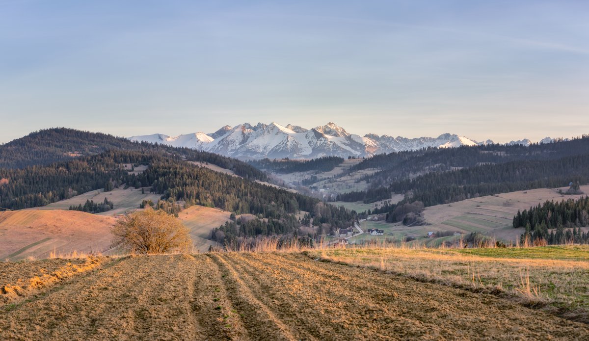
The Tatra National Park, established in 1955, covers approximately 21,164 hectares between Poland and Slovakia. In Zakopane, the main access point from the Polish side, the trails wind through landscapes where alpine meadows alternate with rocky peaks that exceed 2,600 meters. Those who traverse these paths encounter mountain lakes with crystal-clear waters, forests of red spruce, and, in the summer months, blooms of gentians and buttercups that dot the meadows.

The trail network includes over 60 kilometers of marked and signposted paths, with difficulties ranging from easy to very difficult. Zakopane, located at about 850 meters above sea level in the Dunajec valley, serves as the natural starting point for those wishing to explore this alpine region. The trails maintain visible traces throughout the year, although winter snow covers the higher passes from November to April.
The Path of the Five Lakes: a classic moderate hike

One of the most frequented routes is the trail that connects the five glacial lakes in the area, an itinerary that takes about 6-7 hours of walking under normal conditions. The path starts from the Morskie Oko valley and gradually ascends through coniferous forests, where the underbrush hosts blueberries and moss. During the ascent, the landscape progressively opens up: first, the last sparse trees appear, then the alpine meadows with their gray rocks emerging from the ground.
The lakes encountered have well-rooted local names: the first, at about 1,500 meters, is still surrounded by low vegetation. As you proceed to higher altitudes, the water becomes increasingly cold and transparent, reflecting the surrounding rocky walls. The limestone that characterizes the Tatra creates particular formations visible along the trail: vertical cracks, shallow caves, and surfaces smoothed by millennia of glacial action. A practical tip: starting at dawn from Zakopane allows you to complete the hike in a day and avoid returning in the dark; moreover, the months of June and September offer more stable weather conditions compared to July and August, when afternoon thunderstorms are frequent.
The Path of Chochołowska Pass: towards 2,000 meters
For those seeking a greater challenge, the route that ascends the Chochołowska valley to the eponymous pass represents a demanding yet accessible option for hikers with good preparation. This trail, approximately 13 kilometers from the starting point to the pass, traverses different environments: it begins in a narrow valley where the stream flows over smooth rocks, continues through dense forests where sunlight barely filters through the fir trees, and finally emerges into an open landscape dominated by meadows and exposed rocks.
The pass is reached at about 2,000 meters in altitude, where the view extends towards the surrounding peaks and the Slovak valley. During the ascent, it is possible to observe European chamois, slender and gray animals that move on the rocks with surprising agility, especially in the early hours of the morning. The gray limestone rock takes on different shades depending on the light: blue in the shadows, almost white where the sun hits it directly. The trail is well marked with painted stripes on rocks and trees, and features iron chains fixed into the rock in the steepest sections, useful as support during the ascent.
Practical tips and logistical information
Zakopane is about 100 kilometers south of Krakow, reachable in about 2 hours by car or bus. Entry to the park does not require a specific ticket, but it is mandatory to follow the regulations: trails must only be walked during daylight hours, and it is forbidden to stray from marked paths to protect the fragile vegetation. Hiking maps are available at shops in Zakopane and at the park information center.
Clothing should be suitable for weather variations: even in summer, temperatures at altitude drop to 10-15 degrees Celsius, and the wind can be strong. Carrying a backpack with water, energy food, and a waterproof jacket is essential. Mountain huts along the main trails offer shelter and food, and some provide overnight accommodation, useful for those wishing to break a hike into multiple days. The best time to visit is from May to September, when the trails are completely free of snow and weather conditions are generally stable.
