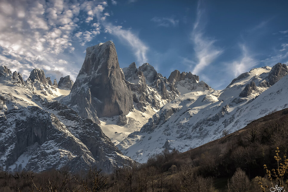
Naranjo de Bulnes (المعروفة باسم Picu Urriellu في Asturian) هي قمة من الحجر الجيري تعود إلى عصر paleozoic ، وتقع في منطقة Macizo الوسطى في Picos de Europa ، Asturias (إسبانيا). ويعتقد أن اسمها Picu Urriellu مشتق من مصطلح Los Urrieles الذي يستخدم لوصف Macizo Central. Naranjo de Bulnes هو جزء من منطقة Cabrales في أستورياس ، ويقع داخل حديقة Picos de Europa الوطنية. ويعود الفضل في الإشارة الخطية الأولى إلى" بيكو أوريلو "بوصفها" نارانجو دي بولنيس " إلى عالم الجيولوجيا والمهندس الألماني فيلهلم شولز ، الذي نشر في عام 1855 أول خريطة طبوغرافية وجيولوجية لأستورياس.The mountain was first scaled from the north face (by the route now known as The Vía Pidal) on 5 August 1904 by Pedro Pidal y Bernaldo de Quirós, marqués de Villaviciosa de Asturias, accompanied by the shepherd Gregorio Perez, called &Quot;El Cainejo" from his place of birth, Caín in León.هناك العديد من الطرق للوصول إلى منطقة Vega Urriellu. ربما تكون أسهل طريقة هي إيقاف السيارة في مدينة سوتريس. من هناك ، وبعد المسار ، توجه إلى" إينفيراليس دي كاباو " ، وبعد ذلك عبر نهر دوجي ومن هناك تسلق إلى" بانديبانو كول " حيث ينتهي المسار ويبدأ ممر المشاة. Once on the footpath head towards the" Majada de la Terenosa " (the shelter of the same name is also located there). The" Colláu Vallejo " is reached from here, which is where the route veers to the south and from where you can begin to make out The Picu Urriellu. ومنذ تلك النقطة على الطريق يستمر بطريقة متعرجة حتى " Vega Urriellu" حيث يوجد المأوى الذي يحمل نفس الاسم ، على ارتفاع 1960m.
The" Pandébano Col " can also be reached from the town Of Bulnes, however this town can only be reached using a footpath or the funicular railway.